
Good Morning!!! 
Well, what should I say?! Today is the most perfect Monday! Why? OK I'll explain it aalll... to you!
1.) No school today... hehehe
2.) The first person I saw to day is YJ  (CREA MAGAZINE!!!.......lol)
3.)The weather is soooooo baetifull.... sorry i mean 'beautiful'. 
(It is  but cold and windy
  . Do you know what i mean? Ohh... OK, iT IS 18C lol. Got it?
  Brrrr... ) sorry. hehehe, it reminds me of WLS somehow
4.) I saw MT.FUJI  from our window!!!
The first time I saw Fuji San my heart  did some tumblings.
Hmmm  I dont want this post to finish here.... What should I do?....
*After 1day 2hours 37 minutes and 09 seconds, mymy decided to post photos of Fuji San (If blogger will allow her...*
I'll post some pictures of Fuji San, would you please tell me what did you feel after seeing it? OK? (*baeyonful... hehe, *beautiful eyes) *I need to use contact first, lol
Mt. Fuji (富士山)*Fuji-san
First I'll post a photo of Fuji-san in Autumn  . Why? Because it is already AUTUMN here in
  lol!!!

Next is...  WINTER !!! Brrrr...

Next, SPRING!!! What enters your mind when someone told you that he/she saw the SPRING off  ?!?
?!?
Of course CHERRY BLOSSOMS!  YIPPEE!!!
 Last but not the least SUMMER!!! Oh my mosquitoes...
 Let's forget about mosqy, OK? How about
 ???
??? 


Mount Fuji is popular becouse of it's very attractive volcanic cone and it is also the highest volcano in Japan (12,388feet).The volcano is currently classified as active with a low risk of eruption. The last recorded eruption occurred in 1707 during the Edo period.
If Japan have Mt.Fuji Philippines have "Mt.Mayon"!!!

Mayon Volcano is an active volcano in the Philippines on the island of Luzon, in the province of Albay in the Bicol Region. Its almost perfectly-shaped cone is considered by some to be the Philippine equivalent of Mount Fuji in Japan.
Mayon is the most active volcano in the country, having erupted over 50 times in the past 400 years. In fact it's last erruption is continuing this year.

The most destructive eruption of Mayon occurred on February 1, 1814.At that time lava flows buried the town of Cagsawa and 1,200 people perished. Only the bell tower of the town's church (above picture) remained above the new surface.
Mt.Pinatubo(4,875feet)

*Yah, I know scary picture, right? 
Mount Pinatubo is an active volcano located on the island of Luzon in the Philippines, at the intersection of the borders of the provinces of Zambales, Tarlac, and Pampanga (remember, I GREW UP IN PAMPANGA. And yes Pinatubo is very near from our house, lol). Before 1991, the mountain was inconspicuous and heavily eroded. It was covered in dense forest which supported a population of several thousand indigenous people, the Aeta, who had fled to the mountains from the lowlands when the Spanish conquered the Philippines in 1565
The volcano's eruption in June 1991 came after 500 years of dormancy, and produced one of the largest and most violent eruptions of the 20th century. Successful predictions of the onset of the climactic eruption led to the evacuation of tens of thousands of people from the surrounding areas, saving many lives, but as the surrounding areas were severely damaged by pyroclastic flows, ash deposits, and later, lahars caused by rainwater remobilising earlier volcanic deposits, thousands of houses were destroyed.
The word 'pinatubo' means 'to have made grow' in the Tagalog and Sambal languages, which may suggest a knowledge of its previous eruption in about AD 1500, although there is no oral tradition among local people of earlier large eruptions. Pinatubo might instead mean a fertile place where crops can be made to grow.
Before the catastrophic eruption of 1991, Pinatubo was an inconspicuous volcano, unknown to most people in the surrounding areas. Its summit was 1,745 m (5,725 ft) above sea level, but only about 600 m above nearby plains, and about 200 m higher than surrounding peaks, which largely obscured it from view. An indigenous people, the Aeta (also spelt Ayta), had lived on the slopes of the volcano and in surrounding areas for several centuries, having fled the lowlands to escape persecution by the Spanish. They were a hunter-gatherer people who were extremely successful in surviving in the dense jungles of the area.
In total, about 30,000 people lived on the flanks of the volcano in barangays (villages) and other small settlements. The dense jungle covering most of the mountain and surrounding peaks supported the hunter-gathering Aeta, while on the surrounding flatter areas, the abundant rainfall (almost 4 m annually) provided by the monsoon climate and the fertile volcanic soils provided excellent conditions for agriculture, and many people grew rice and other staple foods. About 500,000 people continue to live within 40 km of the mountain, with population centres including the 150,000 in Angeles City, and 20,000 at Clark Air Base.
Several important river systems have their sources on Pinatubo, with the major rivers being the Bucao, Santo Tomas, Maloma, Tanguay and Kileng rivers. Before the eruption, these river systems were important ecosystems, but the eruption filled many valleys with deep pyroclastic deposits. Since 1991, the rivers have been clogged with sediment, and the valleys have seen frequent lahars. Studies show that the river systems will take many years yet to recover from the 1991 eruption.
Although there seems to be no local knowledge of the previous large eruptions in the Pinatubo area, several Aeta residents reported in 1991 that their elders recalled small explosions in the past. Pinatubo was a known geothermal area before the 1991 eruption, and small steam explosions are quite common in such areas.
On July 16, 1990, an earthquake of magnitude 7.8 (comparable in size to the 1906 San Francisco earthquake and the 2005 Kashmir Earthquake) struck central Luzon. Its epicentre was about 100 km northeast of Pinatubo, leading some volcanologists to speculate that it might ultimately have triggered the 1991 eruption, although this is impossible to prove conclusively. Two weeks after the earthquake, local residents reported steam coming from the volcano, but scientists visiting the mountain found that small landslides rather than any eruptive activity were responsible.
On March 15, 1991, a succession of earthquakes was felt by villagers on the north-western side of the volcano. Further earthquakes of increasing intensity were felt over the next two weeks, and it became clear some kind of volcanic activity was imminent. On April 2, the volcano awoke, with phreatic eruptions occurring near the summit along a 1.5 km long fissure. Over the next few weeks, small eruptions continued, dusting the surrounding areas with ash. Seismographs detected hundreds of small earthquakes every day.
Scientists immediately installed monitoring equipment and analysed the volcano for clues as to its previous eruptive history. Radiocarbon dating of charcoal found in old volcanic deposits revealed the three major explosive eruptions in recent millennia, about 5500, 3500 and 500 years ago. Geological mapping showed that much of the surrounding plains were formed by lahar deposits from previous eruptions.
Volcanic activity increased throughout April and May. Measurements of sulfur dioxide emission showed a rapid increase from 500 tonnes per day on May 13 to 5,000 tonnes/day by May 28. This implied that there was a rising column of fresh magma beneath the volcano. After May 28, the amount of SO2 being emitted decreased substantially, raising fears that the degassing of the magma had been blocked somehow, leading to a pressure build-up in the magma chamber and a high likelihood of explosive eruptions.
June 15 saw the onset of the climactic eruption. Large tremors starting at 13:42 saturated all the seismographs at Clark Air Base, and by 14:30 all had been rendered inoperative, mostly by pyroclastic density currents. Intense atmospheric pressure variation was also recorded.
(reminder about the above picture: WE DON'T HAVE WINTER IN THE PHILIPPINES lol, AND THAT MEANS WE DON'T HAVE SNOOWWW!!!!) SNOOWWW!!!! 
On the same day, Typhoon Yunya struck the island, passing about 75 km (50 miles) north of the volcano. The typhoon rains made direct visual observations of the eruption impossible, but measurements showed that ash was ejected to heights of 34 km by the most violent phase of the eruption, which lasted about three hours. Pyroclastic flows poured from the summit, reaching as far as 16 km away from it. Typhoon rains mixed with the ash deposits causing massive lahars.
The ash cloud from the volcano covered an area of some 125,000 km² (50,000 mi²), bringing total darkness to much of central Luzon. Almost all of the island received some ashfall, which formed a heavy, rain-saturated snow-like blanket. Tephra fell over most of the South China Sea and ashfall was recorded as far away as Vietnam, Cambodia and Malaysia.
About 300 people were killed by the eruption, mostly by roofs collapsing under the weight of accumulated wet ash, a hazard that was greatly exacerbated by the simultaneous arrival of Typhoon Yunya. The evacuation in the days preceding the eruption certainly saved tens of thousands of lives, and has been hailed as a great success for volcanology and eruption prediction.
However, since the eruption, each rainy season has brought further lahars, which have caused the displacement of thousands of people. Hundreds have died from poor sanitation in relocation camps. Agriculture in the region also suffered badly from the effects of the eruption, with hundreds of square kilometres of formerly arable land being rendered infertile, destroying the livelihoods of thousands of farmers.
The eruption of Pinatubo severely hampered the economic development of the surrounding areas. Extensive damage to buildings and infrastructure cost billions of pesos to repair, and further costs were incurred in constructing dikes and dams to control the post-eruption lahars.
In total, 364 communities and 2.1 million people were affected by the eruption, with livelihoods and houses being damaged or destroyed. More than 8,000 houses were completely destroyed, and a further 73,000 were damaged. In addition to the severe damage sustained by these communities, roads and communications were damaged or destroyed by pyroclastic flows and lahars throughout the areas surrounding the volcanoes. The estimated cost of repairing the damage to infrastructure was 3.8 billion pesos.
Many reforestation projects were destroyed in the eruption, with a total area of 150 square kilometres (37,000 acres) valued at 125 million pesos destroyed. Agriculture was heavily disrupted, with 800 square kilometres (200,000 acres) of rice-growing farmland destroyed, and almost 800,000 head of livestock and poultry killed. The cost to agriculture of eruption effects was estimated to be 1.5 billion pesos.
Damage to healthcare facilities, and the spread of illnesses in relocation facilities, led to soaring death rates in the months following the eruption. Education for thousands of children was seriously disrupted by the destruction of schools in the eruption.
The Aeta people were the hardest hit by the eruption. The total destruction of many villages by pyroclasts and lahar deposits meant that many Aeta were unable to return to their former way of life. After the areas surrounding the volcano were declared safe to return to, those whose villages had not been destroyed moved back, but most people moved instead to government-organised resettlement areas. Conditions on these were poor, with each family receiving only small plots of land, which were not ideal for growing crops. Many Aeta found casual labour working for lowland farmers, and overall Aeta society became much more fragmented, and reliant on and integrated with lowland culture.
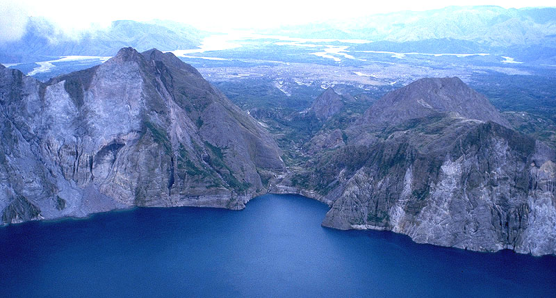
After eruptions ended, a crater lake ( above photo) formed in the 1991 caldera, with the 1992 lava dome forming an island. At first, the lake was small, hot and highly acidic, with a minimum pH of 2 and a temperature of about 40°C. Abundant rainfall cooled and diluted the lake, lowering the temperature to 26°C and raising the pH to 5.5 by 2003.
The lake increased in depth by about 1 metre per month on average, until September 2001, when fears that the walls of the crater might be unstable prompted the Philippine government to order a controlled draining of the lake. 9,000 people were once again evacuated from surrounding areas in case a large flood was accidentally triggered. Workers cut a 5 m notch in the crater rim, and successfully drained about a quarter of the lake's volume.
Taal Volcano- smallest volcano in the world (1,312feet)
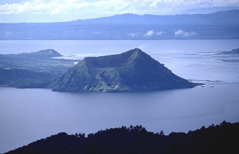
Taal Volcano is an active volcano on the island of Luzon in the Philippines. It consists of an island in Lake Taal, which is situated within a caldera formed by an earlier very large eruption. It is about 50 km from the capital, Manila.
The volcano has erupted violently several times, causing loss of life in the populated areas surrounding the lake. Due to its eruptive history and location close to population centres, the volcano has been designated a Decade Volcano worthy of close study to prevent future natural disasters.
Mt.Arayat(3366feet)

Mount Arayat is an extinct volcano on Luzon Island, Philippines, rising to a height of 1026 m (3366 ft) AGL. There is no recorded eruption of the volcano, and its last activity probably dates to the Holocene era. One academic report indicates activity within the last 2000 years, but it is believed that this refers to the volcano's thermal activity.Ten miles to the west of Mount Arayat is Angeles City and the former Clark Air Base. Mount Pinatubo is located a further ten miles west.It is considered a mystical mountain, the legendary home of the fairy godmother Mariang Sinukuan, and was once believed to contain a wealth of fruit.
*Mt.Arayat is a part of my daily life before, I just need to look at our window and there it is saying "Hi!" to me.
I think by now you would now that I  nature. Well, who doesn't, right?
How about you is there a special 'made by God place' that is very near to your heart?


7 comments:
HI mymy!
I love your blog! It's so cute, funny and full of life. Love your little emoticons. Where did you get them?
Take good care and looking forward to more fun on your blog!
From one BYJ fan to another!
Take care!
hi vegas!
your my first visitor!!!!
really thanks for visiting!
those emoticons are from smiley.smileycentral.com... v^^v
see you around!!!
mymy
holy moly, that was one long post... gotta admit i skimmed through the middle part.
errr... volcanoes, geography ain't my fave topics :p
but hehe, mt fuji always remind me of ice-cream cake...
hehehe...
bb onni, me toooo
ICE-CREAM CAKE!!! :9
sorry...
i just want you and others to remember what pinatubo done...
becouse it really amazes me...
if you go at my house in the Philippines, you'll see that our whole yard is full of white sand...
you're thinking that it's from the beach? nah ah ah...
all of those r lahar
hehe:)
mymy
hey girl. i'm Rachelle (who's living/studying in Osaka). Anyway, I found your blog when I was surfing the net for some photos of Taal and Mayon. Hehe. It was a refreshing find. Nice entry.
what is with the naked shot in there?
seems 'out of place'
nice shots.
its my bad i hot linked that photo from google it WAS mt.fuji months ago
as u can see w/ the older comments no one mentioned it sighs~~~
Post a Comment